Laser radar, also known as LiDAR, has emerged as a cutting-edge active remote sensing technology that outperforms traditional radar in terms of time resolution, spatial accuracy, and long-range detection capabilities. With its ability to precisely measure distance, speed, track objects, and detect targets, it has found extensive applications in both civilian and military sectors, with promising future development prospects.
So, what exactly is laser radar? It operates by using laser beams as information carriers, transmitting data through variations in phase, amplitude, and frequency. By operating at optical frequencies, it can detect even the smallest targets, making it a key innovation in modern optics. Combining the strengths of traditional radar and advanced laser technology, LiDAR represents a sophisticated form of active remote sensing.
What impact can laser radar have on our daily lives? LiDAR integrates technologies such as traditional radar, opto-mechatronics, and computerization, making it a multidisciplinary field rooted in physics. Today, there are numerous types of LiDAR systems, classified based on lasers, functions, and detection methods.
Thanks to its high resolution, sensitivity, and strong anti-clutter capability, LiDAR enables 24/7 observation. It is widely used in environmental monitoring, topographic mapping, high-altitude detection, military operations, and civil vehicles. Its directional nature, high coherence, and monochromaticity have led to rapid development in meteorology, where it helps detect aerosols, clouds, ocean winds, greenhouse gases, temperature, and humidity changes—providing accurate real-time data for aviation safety, weather forecasting, and climate modeling.
In ocean exploration, airborne, shipborne, and underwater LiDAR systems can monitor wave movements, oil pollution, and hydrocarbon reserves in shallow waters. These systems offer faster scanning and more detailed topographic data than sonar, significantly improving measurement efficiency and quality.
LiDAR’s pulse waves can penetrate forests, allowing researchers to analyze echo waveforms and obtain three-dimensional forest structures. This helps estimate tree height, canopy density, and even locate underground structures, supporting both forestry and archaeological research.
With its high angular resolution and short working wavelength, LiDAR can accurately measure distance, velocity, and angle without atmospheric interference. It is lightweight, energy-efficient, and increasingly used in space applications, such as satellite laser ranging, spacecraft navigation, and aerial imaging.
In the military domain, LiDAR supports battlefield surveillance, target detection, obstacle avoidance, and precision strikes. It can scan underwater targets like submarines and mines, proving valuable in both small-scale positioning and large-scale reconnaissance.
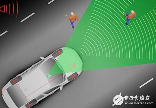
In the automotive industry, LiDAR stands out for its high accuracy and wide detection range. Unlike cameras or traditional radars, it works well in adverse weather conditions, making it an ideal sensor for autonomous vehicles. By scanning the surroundings in 360 degrees, it enhances driving safety and reliability.
Bang 20000
YIWU JUHE TRADING COMPANY , https://www.nx-vapes.com