Laser radar, also known as LiDAR, is an advanced active remote sensing technology that offers precise time and spatial resolution, along with the ability to detect objects at extremely long distances. Unlike traditional radar, which uses radio waves, LiDAR employs laser beams as its information carrier, allowing for highly accurate distance, speed, tracking, and detection capabilities. These features have led to its widespread use in both civilian and military applications, with significant potential for future development.
What is LiDAR?
LiDAR works by emitting laser pulses and measuring the time it takes for the light to return after reflecting off a target. This process allows for the creation of detailed 3D maps and high-resolution data. By modulating the laser’s phase, amplitude, or frequency, LiDAR can gather vast amounts of information about the environment. It combines the strengths of traditional radar with modern laser technology, making it a powerful tool in the field of optical remote sensing.
What impact can LiDAR have on human life?
LiDAR integrates cutting-edge technologies such as optics, radar, and computer systems. It plays a crucial role in various scientific fields and is widely used in environmental monitoring, topographic mapping, atmospheric research, and more. Its high sensitivity and resolution make it ideal for all-weather observation, enabling real-time data collection that supports everything from weather forecasting to climate change studies.
In meteorology, LiDAR helps monitor aerosols, clouds, wind patterns, and greenhouse gases. It provides critical data for aviation safety, weather prediction, and atmospheric modeling. For instance, backscattered LiDAR is used to detect fine particulate matter, while Doppler LiDAR measures wind speed and direction in the atmosphere and oceans.
In ocean exploration, airborne, shipborne, and underwater LiDAR systems are used to monitor wave movements, oil pollution, and underwater structures. These systems offer faster and more accurate measurements than sonar, especially in shallow waters and complex environments.
LiDAR is also valuable in forestry, where it can penetrate dense vegetation to map forest structures and estimate biomass. It helps identify hidden features like underground ruins or archaeological sites, supporting both ecological and historical research.
In space exploration, LiDAR is used for satellite navigation, spacecraft docking, and planetary surface mapping. Its lightweight design, low power consumption, and high accuracy make it ideal for space missions.
In the military, LiDAR is used for surveillance, target detection, obstacle avoidance, and precision strikes. It can scan underwater targets like submarines and mines, offering advantages in both close-range and large-scale operations.
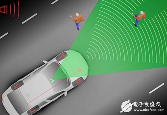
In automotive applications, LiDAR is essential for autonomous vehicles. It provides high-precision, wide-range detection, even in adverse weather conditions like fog and rain. Unlike cameras, which struggle in low visibility, or traditional radars, which lack precision, LiDAR offers a balanced solution, enabling 360-degree environmental scanning for safe and reliable navigation.
JNR Shisha 12000puffs
YIWU JUHE TRADING COMPANY , https://www.nx-vapes.com